Travelling has always been a factor to look up into. We’d never go enough of going on a road trips or even casual outings. In the past years, travelling was not easy and specially finding routes and getting the right map was very difficult but today to make things better we have the Google maps which is definitely as helping hand and a savior while we are out.
With a Google map it pretty easy to locate places and we can travel wherever we want without a fear of getting missed. Google maps app doesn’t simply provide you the map to a destination but it does have so many other great features too, which most of us don’t use.
What we actually do is, get the map and start riding with the directions provided by the map. As the google map helps us with places from anywhere of the world, we doesn’t even need a tour guide today. Along with the ability to provide us the accurate map, the app also have some unique and useful features to help us male our journey easier and better. We can make the experience with the Google map way better if we know how to handle it right. But most of us don’t even know that we can do such things in the map, as some features are hidden and you have to pull it out.
If you are interested to know all those features and learn how to get them done, then you are at the right place. I am going to provide some of the best tips that you can follow doing when you use the Google maps app to locate a place or get a route. So without wasting time let us move on to see a few tips briefly.
To find it, you have to search for the place and swipe up to see more information on it. There you will find photos and sometimes a 360 degree icon through which you can check on the interior and exterior of the building.
Pin your parking point
If you always gets confused of where you parked your vehicle in a big parking slot, then better take use of the parking vehicle location option. By this you can pin the place that you parked your vehicle and even add a note to it with the floor number and so to make it easier to find out.
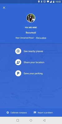
To activate it, when you reach the spot, tap on the blue dot that points your location. Then from the menu that pops up, choose the ‘set as parking location’ option and you can add in the note if required.
Explore
If you have traveled to a new city and you have no idea of what to find there or where to go, then the explore options in the Google map would help you with it.
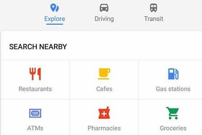
If you are looking for an ATM, bank, mall or even a restaurant you can simply tap on the ‘Explore’ option which is on the bottom of the screen to get it started. There after find the place you want and the map will navigate you to the exact place.
Getting transit information
Travelling in a public transportation in a new country or a city will not be easy if you have to take many transit. You will probably get confused of where to get down and which train or bus you have to catch next. But nothing to worry as Google maps helps us with it too.
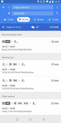
Tap on the get buses, trains or trams schedule and it will show you all the details including the real time departure and the number of interchanges. It will also provide you some alternative route of you can simply walk or ride, which will help you chose the quickly and the easiest option.
So that’s it, now we have checked on a few features that has been in the Google maps for a quite a long time and we didn’t realize it. Using these options would definitely be a great help for you to have a better experience with your travelling using the Google maps. From riding your own vehicle to travelling in bus the Google map will help you out. So i hope this guide would have been useful for you.
If you are interested to know all those features and learn how to get them done, then you are at the right place. I am going to provide some of the best tips that you can follow doing when you use the Google maps app to locate a place or get a route. So without wasting time let us move on to see a few tips briefly.
How to Use Google Maps in Android Phone
Zoom with one finger
If you are riding the vehicle and find it difficult to zoom in and out the app by pinching the screen, then you can do it using your one finger, which is quiet easy to manage up.
To activate this method, all you have to do is double tap and on the second tap do a little longer tap on the screen and then you can easily do so by swiping up to zoom and swipe down to zoom out.
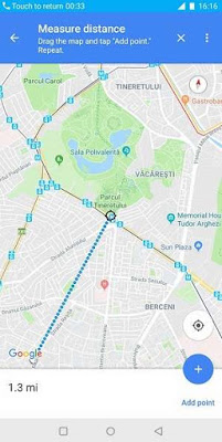
Measuring distance between points
If you are ready to travel to a place and is not sure how far you got to go, then you can check out for the distance between the two points that you are above to travel.
All you will have to do is touch and hold on the place that you want to go to and a red pin will appear on that particular place. Then tap on the name of the place which is on the bottom of the screen.
Next under the place option, scroll down and choose ‘measure distance’. Then move the map and place the black point on the next place that you want to add. That’s it, then it will show you the distance on miles or kilometres in the bottom.
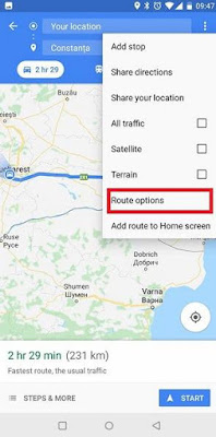
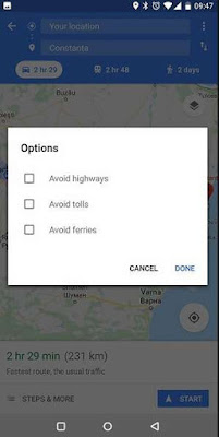
Avoid tolls
If you don’t want to pass tolls or pay extra money for them, then you can chose a free route if their is any. Don’t worry if you don’t know the route towards the free road because Google map will also help you with that.
Go to the ‘route option’ from the settings and simply toggle on the ‘avoid tolls’.
So then it would skip the toll routes and show you a free road. But for your information, skipping toll gates and finding a free route might lead you to go extra miles.
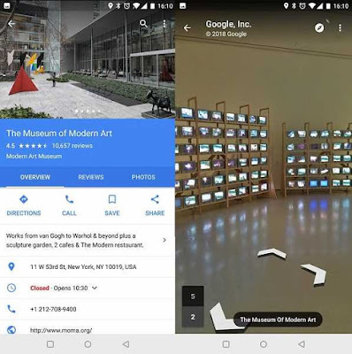
See inside places
If you are planning for an outing and wants to check out the place before you go, you can do so using the google maps. It will provide you with some images and a slight move on map inside some of the famous places like museums, airports or any cultural landmarks.
If you are planning for an outing and wants to check out the place before you go, you can do so using the google maps. It will provide you with some images and a slight move on map inside some of the famous places like museums, airports or any cultural landmarks.
To find it, you have to search for the place and swipe up to see more information on it. There you will find photos and sometimes a 360 degree icon through which you can check on the interior and exterior of the building.
Pin your parking point
If you always gets confused of where you parked your vehicle in a big parking slot, then better take use of the parking vehicle location option. By this you can pin the place that you parked your vehicle and even add a note to it with the floor number and so to make it easier to find out.
To activate it, when you reach the spot, tap on the blue dot that points your location. Then from the menu that pops up, choose the ‘set as parking location’ option and you can add in the note if required.
Explore
If you have traveled to a new city and you have no idea of what to find there or where to go, then the explore options in the Google map would help you with it.
If you are looking for an ATM, bank, mall or even a restaurant you can simply tap on the ‘Explore’ option which is on the bottom of the screen to get it started. There after find the place you want and the map will navigate you to the exact place.
Getting transit information
Travelling in a public transportation in a new country or a city will not be easy if you have to take many transit. You will probably get confused of where to get down and which train or bus you have to catch next. But nothing to worry as Google maps helps us with it too.
Tap on the get buses, trains or trams schedule and it will show you all the details including the real time departure and the number of interchanges. It will also provide you some alternative route of you can simply walk or ride, which will help you chose the quickly and the easiest option.
So that’s it, now we have checked on a few features that has been in the Google maps for a quite a long time and we didn’t realize it. Using these options would definitely be a great help for you to have a better experience with your travelling using the Google maps. From riding your own vehicle to travelling in bus the Google map will help you out. So i hope this guide would have been useful for you.